Reexamining an old variant and discovering a shorter route to Fornovo di Taro
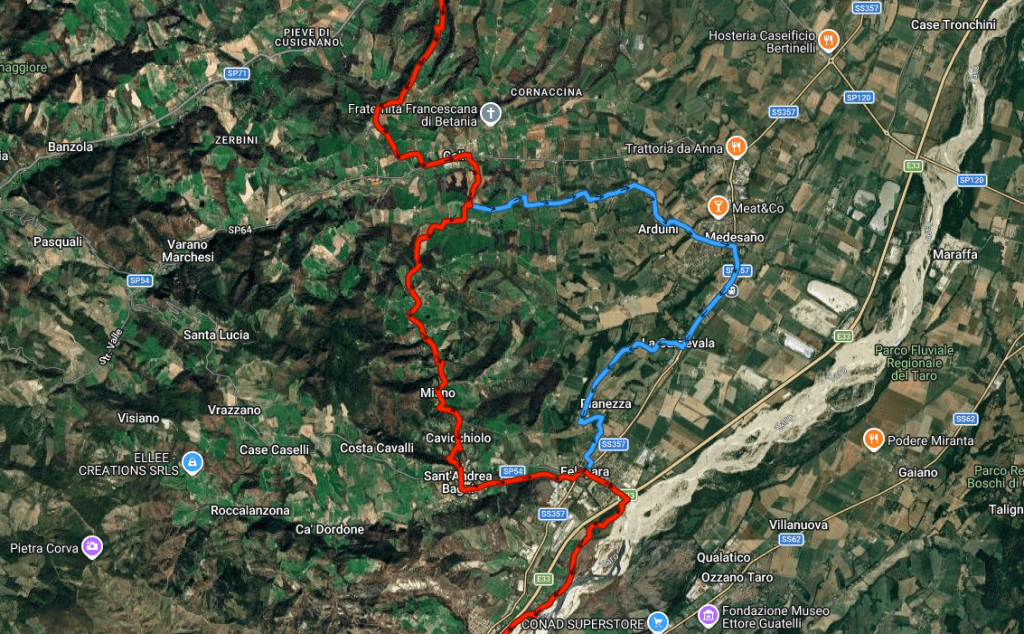
For years I’ve wanted to walk the option to Sant’Andrea Bagni via the Sant’Andrea Bagni Via Francigena variant on the Fidenza to Fornovo di Taro stage. Yesterday I had the chance and I took it since it was a sunny, late winter day and I was itching to get out. The route is a 2-hour drive north of Lucca, so I set off early in the morning, anticipating a full day of walking. The first thing I discovered was that the route marked in my VF2 guidebook (Stage 25, p. 180ff) is no longer passable, though it was once the official variant. What I found instead were markings from another version of the variant that still exist today and make for a pretty enjoyable stage. If you are looking to slightly shorten the distance in the main, official stage, or perhaps if you’re looking for a relaxing overnight of thermal baths, this variant is a real option.
Via Francigena Part Two, Page 180 add:
Stage 25: Fidenza to Fornovo di Taro
- Distance: 33.8km (31.5km via Sant’Andrea Bagni)
- Ascents: 789m (630m via Sant’Andrea Bagni)
- Descent: 720m (559m via Sant’Andrea Bagni)
- Pavement: 63% (55% via Sant’Andrea Bagni)
- Services: (variant after Celle: Sant’Andrea Bagni 23.7km, Felegara 25.7km, Fornovo di Taro 31.5km)
The option to Sant’Andrea Bagni reduces the distance to Fornovo by about 2km, but misses the services of Medesano, the largest town encountered on the stage. In season, Sant’Andrea Bagni is a bustling thermal hotsprings town, with ample hotel accommodation and the option of enjoying the thermal baths, rediscovered in the early 19th c.
P.183 – replace text with this:
Sant’Andrea Bagni Option:
The option to Sant’Andrea Bagni reduces the distance to Fornovo by about 2km, but misses the services of Medesano, the largest town encountered on the stage. Instead of following the ridge of Monte Piè to Medesano, the variant turns south, dropping steeply to the floor of the Rio Camporuota valley, forcing a steep ascent on the other side. Once reaching the pavement of quiet Via La Bionda the route is a breeze until diverting onto forest paths for a few hundred meters before Sant’Andrea Bagni. From there it is an easy walk along a pedestrian trail to Felegara where you pick up the main route.
Once reaching the asphalt road at the top of the ridge of Monte Piè, turn left to go to Medesano or turn right to go to Sant’Andrea Bagni. Turn right and in 50m (before the large stone house that shares the hilltop with the large white cross) turn left and descend very steeply on a tractor road along the fields that heads directly toward the valley floor. Pass farm buildings on your left and turn right, skirting a large pond on your right. Zig left with the road then zag right when it turns, now alongside the Rio Camporuota, here a stream. Follow this muddy tractor track for 150m before crossing the creek on a concrete bridge. Now begin the steep ascent on a dirt (or mud) tractor road among derelict farm buildings and hilly fields, aiming at the top of the ridge ahead.
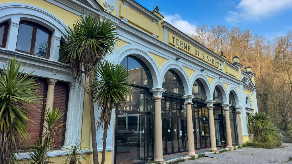
Once at the ridge top, turn right on asphalt Via La Bionda and find yourself at the boundary of the Miano frazione. The hard part is behind you now since all but a few hundred meters will be spent on this quiet country road. Begin a gradual descent starting at the settlement of Ghelfi as the hayfields transition to woods. Begin to climb gradually starting at a lime green former school building, now a charming house. Soon see the tall, slender steeple of San Nicolo of Miano, once in the heart of the now diffuse hamlet. Soon after the church the road becomes Via Cavicchiolo and you begin a long descent through a quiet forest. Views open over the Taro valley toward the left. As you reach the hamlet of Cavicchiolo, you see to the left that the road continues downhill on a series of switchbacks. In the middle of the first switch back, leave the road by turning right and descending steeply on a driveway between two homes, one a stone house with a squat ancient tower. At the end of the driveway continue straight in a grassy path between fences. The path quickly becomes a forest trail, descending quickly along ruts, roots, and rocks. Come to another loop of the Cavicchiolo asphalt road at a perfectly maintained country villa and turn right. In 75m, across from the Villa’s back gate, switch back onto a dirt path that descends once again into the forest. The path ends a few hundred meters later at the curve of the SP54 asphalt road. Go straight on the quiet road, continuing to descend. As the road curves left you are in the upper reaches of town. Continue straight, descending past the yellow Liberty Era terme building passing the modern grey brick building, Hotel Salus, on the left and the red and white Albergo Villa Ombrosa on the right. Continue through a plaza of benches, promenades and fountains, arriving in a few hundred meters at the roundabout in the heart of town.
Sant’Andrea Bagni description (see original)
At the roundabout turn left with the SP54 and follow the sidewalk out of town. The sidewalk ends and on the right side of the street a gravel and asphalt creekside pedestrian path begins, following the Torrente Dordone as it makes its way to its confluence with the Taro River. Notice the Via Francigena kiosk before gradually descending on this pleasant path with ample benches for rest or lunch. The houses of Felegara begin to appear on the left and just afterward turn left at the Via Cisa asphalt road leading into Felegara (this is the auto road to Fornovo and Passo della Cisa). The road soon curves to the right and arrives at a roundabout where you meet the main VF route.


